
The Tour des Ecrins (GR54) Multi-Day Trek
Everything you need to know to plan your trek.
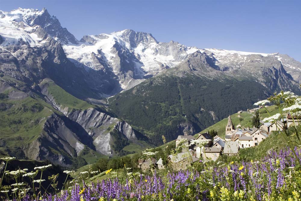
A long distance multi-day mountain trek in the largest and highest National park in the French Alps. With its stunning snow capped mountains and tumbling glaciers the Parc National des Ecrins and GR54 footpath offer an unrivalled mountain journey.
Tour des Ecrins Overview
For breathtaking views of glacier lakes and a real sense of remoteness, take time out to hike the GR54, or the Tour des Écrins. A classic circular trek, it covers 180 km and is one of the most challenging hikes in Europe. Reasonably fit hikers will comfortably complete this trek in the summer without the need for mountaineering skills or equipment in around 7-12 days.
Highlights
Renowned as one of France’s wildest GR treks, the highlights for us are the amazing views of the main peaks of the Ecrins Massif and Lac Lauvitel which blew our mind. High, steep and remote in places, it helps if you have a good head for heights and good scrambling ability, but this adds to the feeling of achievement at the end. The route tops out at 2735 m so shouldn’t cause problems for regular walkers.
Route Map
The Walking
The Tour des Ecrins (GR54) has a reputation for being one of the toughest multi-day treks in the French Alps. Considered by many to be harder than the TMB, this circular 10+ day trek in the Ecrins National Park is over 180 km long, includes 12,800m of ascent and crosses 14 high cols. Although the trek is considered one of the most challenging in the Alps, the nature of the paths and availability of numerous mountain refuges and valley gites means it can be undertaken by anyone of reasonable walking fitness, experience and enthusiasm.
French Alps Trekking also offer a 6-day version which takes in the most remote southern section of the GR54.
The trek is usually started from near the town of Le Bourg-d’Oisans to the northwest of the park and follows a mountainous route around the Barre des Ecrins (the most southerly 4000 m peak in the Alps) as well as passing the spectacular peaks of La Meije (3983 m) and Mt Pelvoux (3946 m) and numerous other mountains over 3500 m. Main villages en route include La Grave, Vallouise and La Chapelle en Valgaudemar.
The steep sided valleys typical of the Ecrins are rich with wildlife, including chamois, ibex, golden eagles, griffon vultures and marmots. A wealth of plants and wild flowers and impressive physical geography will delight nature lovers on a daily basis.
Tour des Ecrins Trek Profile
Number of days walking: 10+ (or 6 day version along the southern section)
Pace: Each day will involve up to 1000 m ascent, between 10-18 km walking and time of 6-9 hours, including stops for photos, rest and refreshment.
Terrain: Good paths with some exposure and short sections of easy scrambling.
Longest day: 18km
Max altitude: The Pas de Cavale – 2735 m
Typical Tour des Ecrins Itinerary
Day 1: La Danchere or Venosc passing lac du Chambon and on to refuge des Clots (1520 m)
Day 2: Refuge des Clots via the Plateau d’Emparis (2365 m), lac noir and lac lerie to Le Chazelet (1800 m)
Day 3: Le Chazelet to Villar D’Arene, up to Col du Arsine (2451 m) and on to Monetier les Bains (1500 m)
Day 4: Monetier to col de l’Eychauda (2425 m) and on to Vallouise.
Day 5: Vallouise to Pas de Cavale (2735 m) and descent to refuge Pre de la Chaumette (1810 m)
Day 6: Ascent to Col du Vallonpierre (2530m) and on to refuge du Clot Xavier Blanc (1700 m)
Day 7: Pass through La Chapelle en Valgaudemar and up to Refuge des Souffles (1975 m)
Day 8: over the Col de la Vaurze (2500 m) and descent to gite in Le Desert du Valjouffrey
Day 9: Le Desert over la Cote Belle (2290 m) to Valsenestre.
Day 10: Valsenestre via Col de la Muzelle (2613 m) and return to La Danchere
Tour des Ecrins Trekking Guides
Available to all fit and adventurous walkers, guided Tour des Ecrins treks run between June and September. The full tour takes approximately 10 days and you can expect to walk about 15 km per day with 1000 m+ vertical ascent each day. The cost generally includes guiding, accommodation in mountain huts and most meals.
GR54 Gear Guide

Practical Information
Are you planning to join an organised trek? Here’s what’s included and not included, the group size, fitness level and accommodation you can typically expect:
What’s Included
All accommodation during the trek in mountain refuges and comfortable valley based gites. All breakfasts and evening meals.
What’s Not Included
Flights to France, travel to start point, travel Insurance, personal hill food/lunch for each day.
Fitness Level
This is a strenuous and high level trek with days covering over 15km distance with 1000+m ascents but is open to all fit and adventurous walkers.
Group Size
This is a small group adult holiday. The group is usually between 4 and 6 like-minded people booking individually, in a couple or as friends together.
Accommodation
Accommodation on the trek is easy to find with plenty of choice of mountain refuges, valley hotels and gites, but be careful as these fill up quickly from mid-July through August and many are closed by October. Early September is perfect if you can manage it – the crowds disappear and the weather is ideal for walking. Wild camping is also an option, but you can’t pitch near the refuges.
Typically, the GR54 starts and ends in Le Bourg-d’Oisans in the valley of the Romanche river, on the road from Grenoble to Briançon, and on the south side of the Col de la Croix de Fer. You’ll find plenty of accommodation options in and around Le Bourg-d’Oisans, including hotels, campsites, and self-catering holiday apartments. Again, make sure you book ahead if you’re planning to do the hike during the summer months.
The Écrins — A Year-Round Destination
The Écrins sits at the crossroads of some of the French Alps’ best ski resorts, so if you’re hooked on the region after your summer trek, it’s worth knowing what’s here in winter. Les Deux Alpes and Alpe d’Huez are both on the northern doorstep of the park — Le Bourg-d’Oisans, where most GR54 hikers start and finish, is the valley town that serves both resorts. To the east, Serre Chevalier offers 250 km of runs above the Guisane Valley that you’ll walk through on day 3 or 4 of the trek. And for the more adventurous, La Grave — which you’ll pass on the northern section of the GR54 — is one of Europe’s most renowned freeride ski destinations, with a single cable car accessing over 2000 m of off-piste vertical beneath La Meije.
FAQ: Planning your GR54 Multi-Day Trek
The GR54, also known as the Tour of the Ecrins Massif, is a long-distance trekking route that encircles the stunning Ecrins National Park in the French Alps in southeastern France.
The entire GR54 loop is approximately 176 kilometers (109 miles) long. Depending on your fitness level and the number of stops you make along the way, the hike typically takes about 10 to 15 days to complete.
The best time to hike the GR54 is typically during the summer months, from late June to early September. This period offers the most favourable weather conditions and ensures that mountain huts and facilities are open.
No, you do not need a permit to hike the GR54. However, it’s a good idea to check in with the Ecrins tourist office for any specific regulations or updates on trail conditions before you start your hike.
The GR54 is considered a challenging trek due to its mountainous terrain and significant elevation changes. Hikers should have prior experience with multi-day hiking and be in good physical condition.
The hike up to the Col de l’Aup Martin, the highest point on the circuit, is high alpine trekking at its finest. And following the climb, the descent to the Pré de la Chaumette is steep and challenging.
Your packing list will differ whether you plan on staying in refuges or camping. For both scenarios, your gear list should include appropriate clothing for varying weather conditions, a comfortable and supportive backpack (approx 50 litres), sturdy hiking boots, rain gear, and a map of the trail. If you plan on camping, add a good-quality, lightweight tent, a sleeping bag, a stove, food supplies, and a headtorch.
Yes, there are several mountain huts, valley based gites and basic camping areas along the GR54, which offer accommodation and dining options. Reservations are strongly recommended during the high season.
The GR54 is a circular route and therefore has multiple access points, and the best one for you depends on your preferences and the direction you plan to hike. Some common starting points include the towns of Briançon, Bourg-d’Oisans, and La Grave. You can reach these towns by train or bus from major cities in France.
Yes, there are drinking water fountains in the small villages/accommodations en route. There are many streams, rivers, and natural water sources along the trail but to use these it’s essential to have a water purification system to ensure the water is safe to drink. Consider carrying a water filter or purification tablets.
In case of an emergency, you can contact the local emergency services by dialing 112. It’s also a good idea to carry a charged mobile phone with you, but remember that mobile reception can be unreliable in some remote areas.
While it’s helpful to know some basic French, especially for communication with locals and obtaining information, many people involved in the tourism industry in this region understand English, especially in popular hiking areas.
Pets are not allowed in the Ecrins National Park. However some sections on the GR54 trail are not in the Park so dogs can be walked on a lead, but in general it is not an option to take a dog on the GR54.
Wild camping is generally permitted from 7pm to 9am. Campfires are not allowed, but you can use a camping stove. There are a few areas where wild camping is not permitted, including around Lac de la Muzelle and Lac Lauvitel. In these areas you can only camp in designated areas. You can camp near refuges, but if you plan to eat at the refuge make sure you book ahead – they only have limited supplies.
Remember that the GR54 is a challenging and remote trek, so proper planning, physical preparation, and thorough research are essential for a safe and enjoyable experience. Always check for the latest information before setting out on your adventure.
Please leave a comment below if you need specific advice for your hiking trip to the Ecrins, or if you have any recommendations to help us improve this guide. Happy holidays!


Hi, I’m wondering if there are any possibilities to do a solo 6-day (self guided) tour across Parc des Ecrins this year. Do you have any recommendations (business) who can arrange this for me? Kind regards, Stijn
Hi Stijn, thanks for your comment.
Yes, it should be possible, but for a 6-day self-guided trip I’d look at a shortened Écrins itinerary rather than the full GR54 / Tour des Écrins, which is a much longer and tougher circuit.
A few companies worth contacting are Altitude Mont Blanc, Undiscovered Mountains, Mont Blanc Experience, and possibly Walkers’ Britain. Altitude Mont Blanc offer a self-guided Tour of Parc des Écrins, while Undiscovered Mountains are based around the Champsaur and Valgaudemar valleys and can arrange flexible self-guided walking holidays in the Écrins.
For a 6-day solo self-guided trip, you could also ask specifically about the Tour du Vieux Chaillol, which is a classic shorter route in the Écrins area and may be a better fit than trying to compress the full GR54. Undiscovered Mountains describe it as a 6-day self-guided alpine walk.
I’d recommend contacting operators as soon as possible, especially for July or August, as refuge and gîte availability can get tight. Also bear in mind that the full GR54 is a serious alpine trek: the official route is around 184 km with 14 passes and 12,800 m of height gain, so a solo self-guided version is best if you’re already confident with mountain navigation, long days and changeable weather.
Hope this helps and good luck planning your trek!
Matt
May I ask what you think would be the earliest date to safely start in June 2025. Thank you.
Hi Michelle, thanks for your message!
There’s still significant snow cover at higher elevations along the GR54 route. Many of the mountain passes (up to 2700 metres) remain snowbound. And, nearby resorts like Les Deux Alpes are still reporting up to 270 cm of snow on the glacier, and fresh snow is expected later this week. Even mid-elevation areas like Puy Saint Vincent are forecasting new snowfall in the coming days, and freeze-thaw conditions continue at altitude.
Because of this, I’d recommend waiting until at least the second or third week of June to begin the trek. This timing is more in line with typical snowmelt patterns and will give the trails time to become safer and more accessible without alpine gear.
If you’re set on early June, keep an eye on snow reports (Mountain-Forecast and J2Ski are good sources) and be prepared to either delay your start or adapt your route depending on conditions.
Hope this helps, stay safe and good luck planning your trek!
Matt
Hi Matt,
We’ve tried contacting Allibert Trekking, who seem to offer what we’re looking for but they’ve proved very uncommunicative. Any suggestions?
Many thanks
Alan
Hi Alan,
Sorry to hear you haven’t had much luck so far! Another company you can try is Altitude Montblanc. They have a guided 10-day Tour des Ecrins trek with a number of guaranteed departures over the summer. Another option is Undiscovered Mountains‘ 7-nights, self-guided walking holiday in the Ecrins National Park.
Let me know how you get on.
Many thanks, Matt
Hi French guide here 😉 if you don’t get any answer from those companies feel free to get in touch with me! I’m used to guide in English and I also guide the GR 54.
Cheers!
Julien
Hello Julien, can you provide me with your email. I have a few questions
Hi Terad, thanks for your comment. I’ll send you a DM with Julien’s email address. Best of luck planning your trip!
Any group treks available in beginning/mid September?
Hi Dana, thanks for your comment!
September is a really nice time to hike the Tour des Écrins (GR54), with cooler yet stable weather and fewer crowds. Having said that, mid-September is really the latest date if you want to join a group trek and stay in mountain refuges. Later than that and the mountain refuges start to close.
Altitude Montblanc has a group departure at the beginning of September. If you want to go later, you can go “self-guided”.
Another option is a 6-day hut-to-hut hiking tour around the Olan in the Écrins National Park with Explore-Share.
Hope that helps, good luck planning your trip!
Matt
My husband and I are interested in walking the GR54 this summer. The only problem is that I have coeliac disease and am wondering if the refuges would be able to provide gluten free food. If you think that would be a problem, is it possible to tailor the walk so we are in hotel or gîte accommodation, where there might be more chance of gluten free food. I can carry some basics like bread and pasta, but it would be problematic to carry ten day’s worth.if you can advise, that would be most helpful.
Hi Sheila, thanks for your comment. Great to hear you’re planning to hike the GR54!
I would suggest that you’ll struggle to find gluten free options in some of the refuges. But, if you are prepared to carry some GF bread and pasta, I think you could build an itinerary that works. However, the easiest option is to join a hiking tour that offers transfers from the route to hotel accommodation. ALLIBERT Trekking has a 7-day itinerary taking in the best of the Ecrins with about 5h30 of hiking per day, and they’ll transport your main bag, so you just need to carry a day pack. Here’s a link: Tour of the Ecrins comfort in freedom” stay
Hope that helps,
Matt
Hi Sheila, I also asked my friend Darren McAulay from French Alps Trekking about finding gluten free food along the trek. He said the following:
Thanks Matt, that’s very helpful. We’ll get in touch with Allibert Trekking. You mentioned your friend from French Alps Trekking. Do they offer something similar – but not in the Ecrins? Thanks again.
Hi Alan, you’re very welcome.
Darren from French Alps Trekking is planning to run a few guided hikes this summer in the Ecrins, but only for select dates, so it is certainly worth contacting him. There’s a contact form on his website (by the way, he’s back from Antarctica now).
Best of luck, Matt